
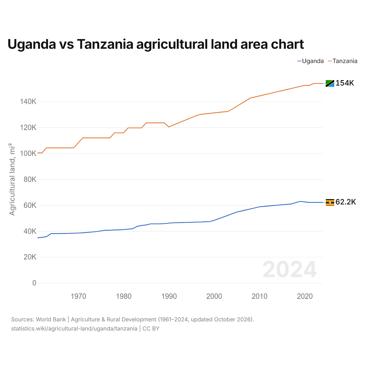
Uganda vs Tanzânia: gráfico da área de terras agrícolas
| Ano | Terras agrícolas, km² | |
|---|---|---|
| Uganda | Tanzânia | |
| 2024 | 160.970 | 398.770 |
| 2023 | 160.970 | 398.770 |
| 2022 | 160.970 | 398.770 |
| 2021 | 160.970 | 394.993 |
| 2020 | 162.010 | 395.004 |
| 2019 | 163.050 | 392.900 |
| 2018 | 160.460 | 390.788 |
| 2017 | 157.870 | 388.676 |
| 2016 | 157.114 | 386.564 |
| 2015 | 156.358 | 384.452 |
| 2014 | 155.530 | 382.340 |
| 2013 | 154.703 | 380.228 |
| 2012 | 153.875 | 378.116 |
| 2011 | 153.048 | 376.004 |
| 2010 | 152.220 | 373.891 |
| 2009 | 150.111 | 371.779 |
| 2008 | 148.002 | 369.667 |
| 2007 | 145.893 | 364.118 |
| 2006 | 143.784 | 358.658 |
| 2005 | 141.675 | 353.098 |
| 2004 | 138.364 | 347.538 |
| 2003 | 135.053 | 342.678 |
| 2002 | 131.742 | 341.989 |
| 2001 | 128.431 | 341.000 |
| 2000 | 125.120 | 340.000 |
| 1999 | 122.620 | 339.000 |
| 1998 | 122.420 | 338.000 |
| 1997 | 121.720 | 337.030 |
| 1996 | 121.720 | 334.220 |
| 1995 | 121.220 | 330.500 |
| 1994 | 121.020 | 326.780 |
| 1993 | 120.820 | 323.060 |
| 1992 | 120.520 | 319.340 |
| 1991 | 120.320 | 315.620 |
| 1990 | 119.620 | 311.900 |
| 1989 | 118.620 | 320.000 |
| 1988 | 118.170 | 320.000 |
| 1987 | 118.170 | 320.000 |
| 1986 | 118.170 | 320.000 |
| 1985 | 116.000 | 320.000 |
| 1984 | 115.000 | 310.000 |
| 1983 | 113.000 | 310.000 |
| 1982 | 108.400 | 310.000 |
| 1981 | 107.600 | 310.000 |
| 1980 | 106.800 | 300.000 |
| 1979 | 106.100 | 300.000 |
| 1978 | 106.100 | 300.000 |
| 1977 | 105.380 | 290.000 |
| 1976 | 105.380 | 290.000 |
| 1975 | 104.070 | 290.000 |
| 1974 | 102.640 | 290.000 |
| 1973 | 101.800 | 290.000 |
| 1972 | 101.000 | 290.000 |
| 1971 | 100.300 | 290.000 |
| 1970 | 99.800 | 280.000 |
| 1969 | 99.500 | 270.000 |
| 1968 | 99.250 | 270.000 |
| 1967 | 98.880 | 270.000 |
| 1966 | 98.850 | 270.000 |
| 1965 | 98.710 | 270.000 |
| 1964 | 98.730 | 270.000 |
| 1963 | 92.580 | 270.000 |
| 1962 | 91.140 | 260.000 |
| 1961 | 90.180 | 260.000 |
As terras agrícolas ocupam 160.970 km² (62.151 mi²) em Uganda e 398.770 km² (153.966 mi²) na Tanzânia: a área agrícola da Tanzânia é 2,5 vezes a de Uganda. Em 1961, ocupavam 90.180 km² (34.819 mi²) em Uganda e 260.000 km² (100.387 mi²) na Tanzânia; a área agrícola da Tanzânia era então 2,9 vezes a de Uganda.
As terras agrícolas ocupam 80,3% da área terrestre de Uganda e 45,1% da área da Tanzânia; as terras aráveis, 43,6% e 15,5%.
Uganda vs Tanzânia: terras agrícolas, área e % da área terrestre
 Uganda |
 Tanzânia |
|
|---|---|---|
| Terras agrícolas | 160.970 km² | 398.770 km² |
| Terras agrícolas, % | 80,3% | 45,1% |
| Terras aráveis | 87.513 km² | 137.018 km² |
| Terras aráveis, % | 43,6% | 15,5% |
| Culturas permanentes | 27.477 km² | 21.982 km² |
| Culturas permanentes, % | 13,7% | 2,5% |
| Prados e pastagens | 45.980 km² | 239.770 km² |
| Prados e pastagens, % | 22,9% | 27,1% |
| Terras aráveis por pessoa | 0,17 ha por pessoa | 0,2 ha por pessoa |
| Posição mundial por terras agrícolas | 57º de 194 | 28º de 194 |
| Posição mundial por terras aráveis | 29º de 191 | 23º de 191 |
| Posição mundial por terras aráveis por pessoa | 75º de 191 | 64º de 191 |
Comparar as terras agrícolas de 2 países quaisquer
Fontes:
- Banco Mundial | Agriculture & Rural Development (1961–2024, atualizado em outubro de 2026)
Creative Commons Atribuição (CC BY): você pode copiar, compartilhar, adaptar e reutilizar este conteúdo, inclusive para fins comerciais, desde que cite o statistics.wiki e indique as alterações que fizer. As fontes listadas acima podem ter suas próprias condições de licença.