
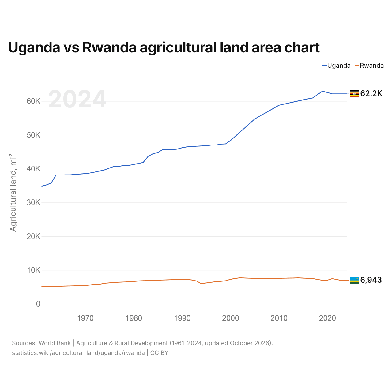
Uganda vs Ruanda: gráfico da área de terras agrícolas
1x
| Ano | Terras agrícolas, km² | |
|---|---|---|
| Uganda | Ruanda | |
| 2024 | 160.970 | 17.981 |
| 2023 | 160.970 | 17.890 |
| 2022 | 160.970 | 18.617 |
| 2021 | 160.970 | 19.337 |
| 2020 | 162.010 | 18.145 |
| 2019 | 163.050 | 18.095 |
| 2018 | 160.460 | 18.700 |
| 2017 | 157.870 | 19.415 |
| 2016 | 157.114 | 19.581 |
| 2015 | 156.358 | 19.756 |
| 2014 | 155.530 | 19.921 |
| 2013 | 154.703 | 19.836 |
| 2012 | 153.875 | 19.752 |
| 2011 | 153.048 | 19.677 |
| 2010 | 152.220 | 19.592 |
| 2009 | 150.111 | 19.507 |
| 2008 | 148.002 | 19.423 |
| 2007 | 145.893 | 19.249 |
| 2006 | 143.784 | 19.394 |
| 2005 | 141.675 | 19.540 |
| 2004 | 138.364 | 19.685 |
| 2003 | 135.053 | 19.840 |
| 2002 | 131.742 | 19.985 |
| 2001 | 128.431 | 19.525 |
| 2000 | 125.120 | 18.825 |
| 1999 | 122.620 | 17.735 |
| 1998 | 122.420 | 17.275 |
| 1997 | 121.720 | 17.075 |
| 1996 | 121.720 | 16.575 |
| 1995 | 121.220 | 16.075 |
| 1994 | 121.020 | 15.490 |
| 1993 | 120.820 | 17.540 |
| 1992 | 120.520 | 18.340 |
| 1991 | 120.320 | 18.740 |
| 1990 | 119.620 | 18.780 |
| 1989 | 118.620 | 18.540 |
| 1988 | 118.170 | 18.530 |
| 1987 | 118.170 | 18.420 |
| 1986 | 118.170 | 18.300 |
| 1985 | 116.000 | 18.190 |
| 1984 | 115.000 | 18.080 |
| 1983 | 113.000 | 17.900 |
| 1982 | 108.400 | 17.750 |
| 1981 | 107.600 | 17.600 |
| 1980 | 106.800 | 17.150 |
| 1979 | 106.100 | 16.970 |
| 1978 | 106.100 | 16.800 |
| 1977 | 105.380 | 16.650 |
| 1976 | 105.380 | 16.390 |
| 1975 | 104.070 | 16.120 |
| 1974 | 102.640 | 15.840 |
| 1973 | 101.800 | 15.050 |
| 1972 | 101.000 | 15.080 |
| 1971 | 100.300 | 14.480 |
| 1970 | 99.800 | 14.040 |
| 1969 | 99.500 | 13.970 |
| 1968 | 99.250 | 13.830 |
| 1967 | 98.880 | 13.750 |
| 1966 | 98.850 | 13.650 |
| 1965 | 98.710 | 13.550 |
| 1964 | 98.730 | 13.450 |
| 1963 | 92.580 | 13.350 |
| 1962 | 91.140 | 13.250 |
| 1961 | 90.180 | 13.150 |
As terras agrícolas ocupam 160.970 km² (62.151 mi²) em Uganda e 17.981 km² (6.943 mi²) em Ruanda: a área agrícola de Uganda é 9,0 vezes a de Ruanda. Em 1961, ocupavam 90.180 km² (34.819 mi²) em Uganda e 13.150 km² (5.077 mi²) em Ruanda; a área agrícola de Uganda era então 6,9 vezes a de Ruanda.
As terras agrícolas ocupam 80,3% da área terrestre de Uganda e 75,7% da área de Ruanda; as terras aráveis, 43,6% e 48,9%.
Uganda vs Ruanda: terras agrícolas, área e % da área terrestre
 Uganda |
 Ruanda |
|
|---|---|---|
| Terras agrícolas | 160.970 km² | 17.981 km² |
| Terras agrícolas, % | 80,3% | 75,7% |
| Terras aráveis | 87.513 km² | 11.624 km² |
| Terras aráveis, % | 43,6% | 48,9% |
| Culturas permanentes | 27.477 km² | 5.112 km² |
| Culturas permanentes, % | 13,7% | 21,5% |
| Prados e pastagens | 45.980 km² | 1.245 km² |
| Prados e pastagens, % | 22,9% | 5,2% |
| Terras aráveis por pessoa | 0,17 ha por pessoa | 0,08 ha por pessoa |
| Posição mundial por terras agrícolas | 57º de 194 | 120º de 194 |
| Posição mundial por terras aráveis | 29º de 191 | 100º de 191 |
| Posição mundial por terras aráveis por pessoa | 75º de 191 | 125º de 191 |
Comparar as terras agrícolas de 2 países quaisquer
Fontes:
- Banco Mundial | Agriculture & Rural Development (1961–2024, atualizado em outubro de 2026)
Creative Commons Atribuição (CC BY): você pode copiar, compartilhar, adaptar e reutilizar este conteúdo, inclusive para fins comerciais, desde que cite o statistics.wiki e indique as alterações que fizer. As fontes listadas acima podem ter suas próprias condições de licença.