
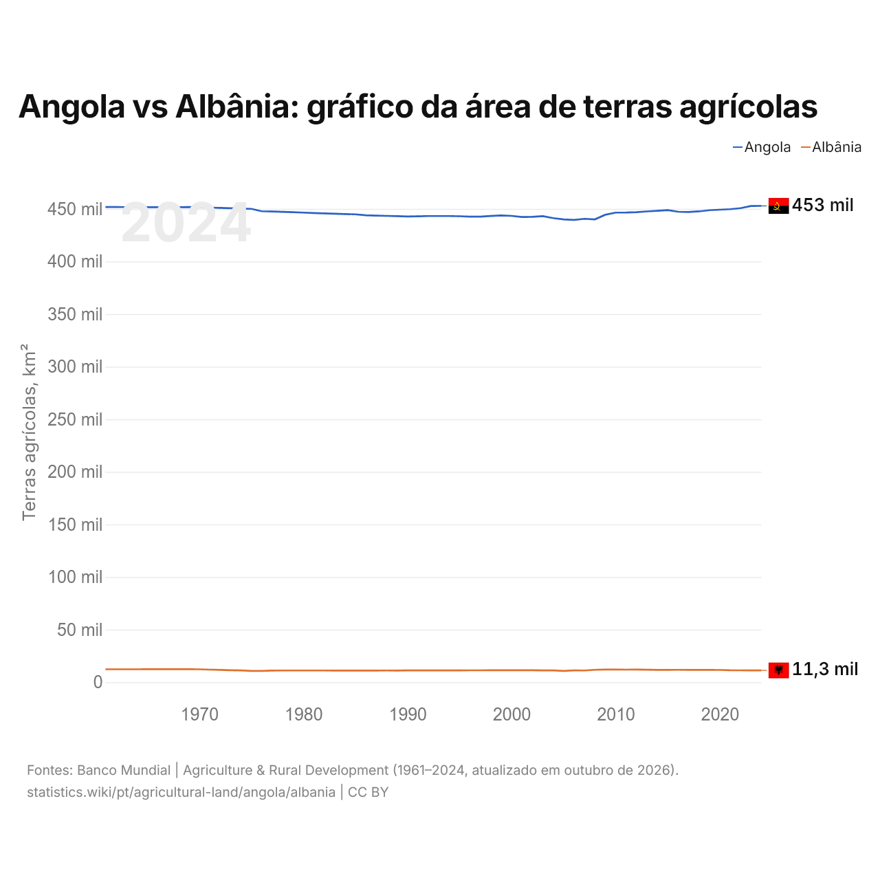
Angola vs Albânia: gráfico da área de terras agrícolas
| Ano | Terras agrícolas, km² | |
|---|---|---|
| Angola | Albânia | |
| 2024 | 452.854 | 11.265 |
| 2023 | 452.787 | 11.289 |
| 2022 | 450.693 | 11.356 |
| 2021 | 449.726 | 11.363 |
| 2020 | 449.263 | 11.656 |
| 2019 | 448.784 | 11.740 |
| 2018 | 447.646 | 11.741 |
| 2017 | 447.061 | 11.743 |
| 2016 | 447.306 | 11.817 |
| 2015 | 448.814 | 11.743 |
| 2014 | 448.192 | 11.743 |
| 2013 | 447.602 | 11.873 |
| 2012 | 446.878 | 12.013 |
| 2011 | 446.536 | 12.010 |
| 2010 | 446.490 | 12.013 |
| 2009 | 444.410 | 12.013 |
| 2008 | 440.081 | 11.810 |
| 2007 | 440.596 | 11.190 |
| 2006 | 439.523 | 11.200 |
| 2005 | 439.978 | 10.770 |
| 2004 | 441.256 | 11.220 |
| 2003 | 443.142 | 11.210 |
| 2002 | 442.514 | 11.400 |
| 2001 | 442.277 | 11.390 |
| 2000 | 443.346 | 11.440 |
| 1999 | 443.772 | 11.450 |
| 1998 | 443.242 | 11.393 |
| 1997 | 442.614 | 11.347 |
| 1996 | 442.589 | 11.310 |
| 1995 | 443.020 | 11.270 |
| 1994 | 443.218 | 11.260 |
| 1993 | 443.220 | 11.260 |
| 1992 | 443.222 | 11.270 |
| 1991 | 443.007 | 11.270 |
| 1990 | 442.793 | 11.210 |
| 1989 | 443.078 | 11.100 |
| 1988 | 443.364 | 11.170 |
| 1987 | 443.649 | 11.110 |
| 1986 | 443.934 | 11.110 |
| 1985 | 444.820 | 11.120 |
| 1984 | 445.105 | 11.130 |
| 1983 | 445.441 | 11.100 |
| 1982 | 445.776 | 11.140 |
| 1981 | 446.062 | 11.160 |
| 1980 | 446.497 | 11.180 |
| 1979 | 446.832 | 11.170 |
| 1978 | 447.218 | 11.140 |
| 1977 | 447.503 | 11.090 |
| 1976 | 447.789 | 10.750 |
| 1975 | 450.074 | 10.800 |
| 1974 | 450.360 | 11.220 |
| 1973 | 450.645 | 11.460 |
| 1972 | 450.930 | 11.740 |
| 1971 | 451.216 | 12.000 |
| 1970 | 451.501 | 12.300 |
| 1969 | 451.787 | 12.350 |
| 1968 | 451.672 | 12.400 |
| 1967 | 451.657 | 12.440 |
| 1966 | 451.643 | 12.400 |
| 1965 | 451.628 | 12.370 |
| 1964 | 451.714 | 12.300 |
| 1963 | 451.699 | 12.330 |
| 1962 | 451.785 | 12.320 |
| 1961 | 451.770 | 12.320 |
As terras agrícolas ocupam 452.854 km² (174.848 mi²) em Angola e 11.265 km² (4.349 mi²) na Albânia: a área agrícola de Angola é 40 vezes a da Albânia. Em 1961, ocupavam 451.770 km² (174.429 mi²) em Angola e 12.320 km² (4.757 mi²) na Albânia; a área agrícola de Angola era então 37 vezes a da Albânia.
As terras agrícolas ocupam 36,3% da área terrestre de Angola e 41,1% da área da Albânia; as terras aráveis, 3,7% e 21,5%.
Angola vs Albânia: terras agrícolas, área e % da área terrestre
 Angola |
 Albânia |
|
|---|---|---|
| Terras agrícolas | 452.854 km² | 11.265 km² |
| Terras agrícolas, % | 36,3% | 41,1% |
| Terras aráveis | 45.673 km² | 5.897 km² |
| Terras aráveis, % | 3,7% | 21,5% |
| Culturas permanentes | 3.571 km² | 876 km² |
| Culturas permanentes, % | 0,3% | 3,2% |
| Prados e pastagens | 403.610 km² | 4.492 km² |
| Prados e pastagens, % | 32,4% | 16,4% |
| Terras aráveis por pessoa | 0,12 ha por pessoa | 0,25 ha por pessoa |
| Posição mundial por terras agrícolas | 20º de 194 | 138º de 194 |
| Posição mundial por terras aráveis | 51º de 191 | 120º de 191 |
| Posição mundial por terras aráveis por pessoa | 96º de 191 | 38º de 191 |
Comparar as terras agrícolas de 2 países quaisquer
Fontes:
- Banco Mundial | Agriculture & Rural Development (1961–2024, atualizado em outubro de 2026)
Creative Commons Atribuição (CC BY): você pode copiar, compartilhar, adaptar e reutilizar este conteúdo, inclusive para fins comerciais, desde que cite o statistics.wiki e indique as alterações que fizer. As fontes listadas acima podem ter suas próprias condições de licença.