
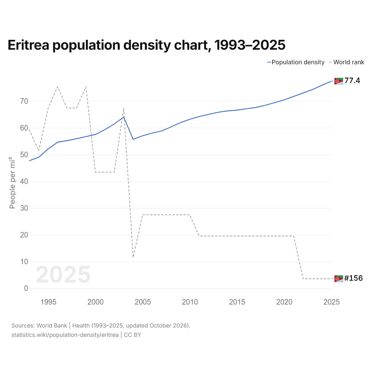
Eritrea population density chart, 1993–2025
| Year | People per mi² | World rank |
|---|---|---|
| 2025 | 77.4 | #156 |
| 2024 | 75.9 | #156 |
| 2023 | 74.3 | #156 |
| 2022 | 73 | #156 |
| 2021 | 71.7 | #154 |
| 2020 | 70.4 | #154 |
| 2019 | 69.4 | #154 |
| 2018 | 68.4 | #154 |
| 2017 | 67.6 | #154 |
| 2016 | 67.1 | #154 |
| 2015 | 66.6 | #154 |
| 2014 | 66.3 | #154 |
| 2013 | 65.8 | #154 |
| 2012 | 65 | #154 |
| 2011 | 64.2 | #154 |
| 2010 | 63.2 | #153 |
| 2009 | 61.9 | #153 |
| 2008 | 60.3 | #153 |
| 2007 | 58.8 | #153 |
| 2006 | 58 | #153 |
| 2005 | 57 | #153 |
| 2004 | 55.7 | #155 |
| 2003 | 64 | #148 |
| 2002 | 61.4 | #151 |
| 2001 | 59.3 | #151 |
| 2000 | 57.5 | #151 |
| 1999 | 56.7 | #147 |
| 1998 | 55.9 | #148 |
| 1997 | 55.2 | #148 |
| 1996 | 54.6 | #147 |
| 1995 | 52.1 | #148 |
| 1994 | 49 | #150 |
| 1993 | 47.7 | #149 |
In 2025, Eritrea's population density was 77.4 per mi² (29.9 per km²), up from 47.7 per mi² (18.4 per km²) in 1993. It was the 156th most densely populated country in the world, a rank it has held since 2022. Its highest rank was 147th, last held in 1999.
In 2025, Eritrea's population density was the 40th highest of the 54 countries of Africa, where it ranged from Namibia's 9.84 per mi² (3.8 per km²) to Mauritius' 1,611 per mi² (622 per km²). Eritrea's was 47% of the world's population density of 164 per mi² (63.4 per km²).
Eritrea in the world population density ranking, 2025
| Rank | Country | Population density | Population | Land area | |
|---|---|---|---|---|---|
| 153 |
 Somalia |
81.1 per mi² (31.3 per km²) | 19,654,739 | 242,217 mi² (627,340 km²) | vs Somalia |
| 154 |
 Angola |
81.1 per mi² (31.3 per km²) | 39,040,039 | 481,354 mi² (1,246,700 km²) | |
| 155 |
 Solomon Islands |
77.6 per mi² (30 per km²) | 838,645 | 10,807 mi² (27,990 km²) | |
| 156 |
 Eritrea |
77.3 per mi² (29.9 per km²) | 3,607,003 | 46,641 mi² (120,800 km²) | |
| 157 |
 Latvia |
76.9 per mi² (29.7 per km²) | 1,847,785 | 24,027 mi² (62,230 km²) | |
| 158 |
 Zambia |
76.3 per mi² (29.5 per km²) | 21,913,874 | 287,024 mi² (743,390 km²) | |
| 159 |
 Sudan |
71.6 per mi² (27.7 per km²) | 51,662,147 | 721,239 mi² (1,868,000 km²) |
Compare the population density of Eritrea with other countries
Sources:
- World Bank | Health (1993–2025, updated October 2026)
- U.S. Census Bureau (2025, updated October 2026)
Creative Commons Attribution (CC BY): you may copy, share, adapt and reuse this content, also commercially, as long as you credit statistics.wiki and note any changes you made. The sources listed above may have their own license terms.