
Equatorial Guinea population density chart, 1961–2025
| Year | People per mi² | World rank |
|---|---|---|
| 2025 | 179 | #122 |
| 2024 | 175 | #122 |
| 2023 | 171 | #123 |
| 2022 | 167 | #124 |
| 2021 | 162 | #125 |
| 2020 | 159 | #125 |
| 2019 | 154 | #126 |
| 2018 | 149 | #126 |
| 2017 | 144 | #126 |
| 2016 | 139 | #127 |
| 2015 | 134 | #129 |
| 2014 | 129 | #132 |
| 2013 | 124 | #132 |
| 2012 | 119 | #135 |
| 2011 | 115 | #135 |
| 2010 | 110 | #135 |
| 2009 | 105 | #138 |
| 2008 | 100 | #140 |
| 2007 | 95.6 | #141 |
| 2006 | 91.4 | #142 |
| 2005 | 87.5 | #141 |
| 2004 | 83.1 | #142 |
| 2003 | 78.2 | #145 |
| 2002 | 73.6 | #146 |
| 2001 | 69.2 | #146 |
| 2000 | 65 | #147 |
| 1999 | 61.6 | #144 |
| 1998 | 59.3 | #144 |
| 1997 | 57 | #145 |
| 1996 | 54.9 | #146 |
| 1995 | 52.8 | #146 |
| 1994 | 50.8 | #146 |
| 1993 | 49 | #147 |
| 1992 | 47.1 | #145 |
| 1991 | 45.3 | #131 |
| 1990 | 43.8 | #129 |
| 1989 | 42.2 | #130 |
| 1988 | 40.7 | #130 |
| 1987 | 39.1 | #130 |
| 1986 | 37.3 | #130 |
| 1985 | 35.5 | #131 |
| 1984 | 33.7 | #131 |
| 1983 | 31.6 | #131 |
| 1982 | 29.8 | #132 |
| 1981 | 28 | #133 |
| 1980 | 26.7 | #133 |
| 1979 | 25.9 | #134 |
| 1978 | 25.6 | #134 |
| 1977 | 25.6 | #133 |
| 1976 | 25.9 | #131 |
| 1975 | 26.7 | #130 |
| 1974 | 27.2 | #130 |
| 1973 | 28 | #130 |
| 1972 | 28.5 | #128 |
| 1971 | 29.3 | #126 |
| 1970 | 29.5 | #124 |
| 1969 | 29.8 | #122 |
| 1968 | 29.5 | #122 |
| 1967 | 28.7 | #122 |
| 1966 | 28.2 | #122 |
| 1965 | 27.5 | #122 |
| 1964 | 26.9 | #122 |
| 1963 | 26.4 | #122 |
| 1962 | 25.9 | #121 |
| 1961 | 25.4 | #122 |
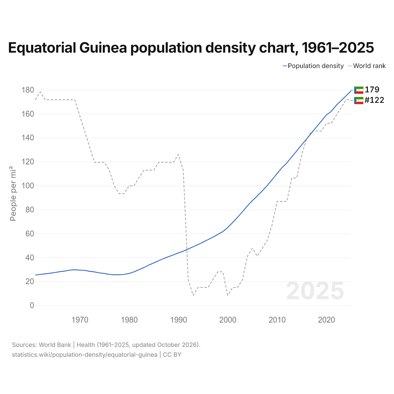
In 2025, Equatorial Guinea's population density was 179 per mi² (69.1 per km²), up from 25.4 per mi² (9.8 per km²) in 1961. It was the 122nd most densely populated country in the world, a rank it has held since 2024. Its highest rank was 121st, last held in 1962.
In 2025, Equatorial Guinea's population density was the 28th highest of the 54 countries of Africa, where it ranged from Namibia's 9.84 per mi² (3.8 per km²) to Mauritius' 1,611 per mi² (622 per km²). Equatorial Guinea's was close to the world's population density of 164 per mi² (63.4 per km²).
Equatorial Guinea in the world population density ranking, 2025
| Rank | Country | Population density | Population | Land area | |
|---|---|---|---|---|---|
| 119 |
 North Macedonia |
187 per mi² (72.2 per km²) | 1,820,909 | 9,737 mi² (25,220 km²) | |
| 120 |
 Moldova |
185.7 per mi² (71.7 per km²) | 2,360,527 | 12,714 mi² (32,930 km²) | |
| 121 |
 Croatia |
179.4 per mi² (69.3 per km²) | 3,876,200 | 21,606 mi² (55,960 km²) | |
| 122 |
 Equatorial Guinea |
179 per mi² (69.1 per km²) | 1,938,431 | 10,831 mi² (28,052 km²) | |
| 123 |
 Mexico |
175.8 per mi² (67.9 per km²) | 131,946,900 | 750,563 mi² (1,943,950 km²) | |
| 124 |
 Ukraine |
174.2 per mi² (67.3 per km²) | 38,980,376 | 223,708 mi² (579,400 km²) | |
| 125 |
 Afghanistan |
174.1 per mi² (67.2 per km²) | 43,844,111 | 251,827 mi² (652,230 km²) |
Compare the population density of Equatorial Guinea with other countries
Sources:
- World Bank | Health (1961–2025, updated October 2026)
- U.S. Census Bureau (2025, updated October 2026)
Creative Commons Attribution (CC BY): you may copy, share, adapt and reuse this content, also commercially, as long as you credit statistics.wiki and note any changes you made. The sources listed above may have their own license terms.