
Guinea forest area chart and figures
1x
| Year | Forest area, mi² | World rank |
|---|---|---|
| Forest area | ||
| 2024 | 19,013 | #71 |
| 2023 | 19,272 | #71 |
| 2022 | 19,530 | #71 |
| 2021 | 19,789 | #72 |
| 2020 | 20,048 | #72 |
| 2019 | 20,306 | #72 |
| 2018 | 20,565 | #72 |
| 2017 | 20,824 | #72 |
| 2016 | 21,082 | #72 |
| 2015 | 21,341 | #72 |
| 2014 | 21,600 | #72 |
| 2013 | 21,858 | #72 |
| 2012 | 22,117 | #71 |
| 2011 | 22,376 | #71 |
| 2010 | 22,634 | #71 |
| 2009 | 22,893 | #71 |
| 2008 | 23,152 | #71 |
| 2007 | 23,411 | #70 |
| 2006 | 23,669 | #70 |
| 2005 | 23,928 | #70 |
| 2004 | 24,187 | #70 |
| 2003 | 24,445 | #69 |
| 2002 | 24,704 | #68 |
| 2001 | 24,962 | #68 |
| 2000 | 25,221 | #67 |
| 1999 | 25,480 | #67 |
| 1998 | 25,738 | #68 |
| 1997 | 25,997 | #69 |
| 1996 | 26,256 | #69 |
| 1995 | 26,514 | #69 |
| 1994 | 26,773 | #69 |
| 1993 | 27,032 | #69 |
| 1992 | 27,290 | #69 |
| 1991 | 27,549 | #69 |
| 1990 | 27,808 | #68 |
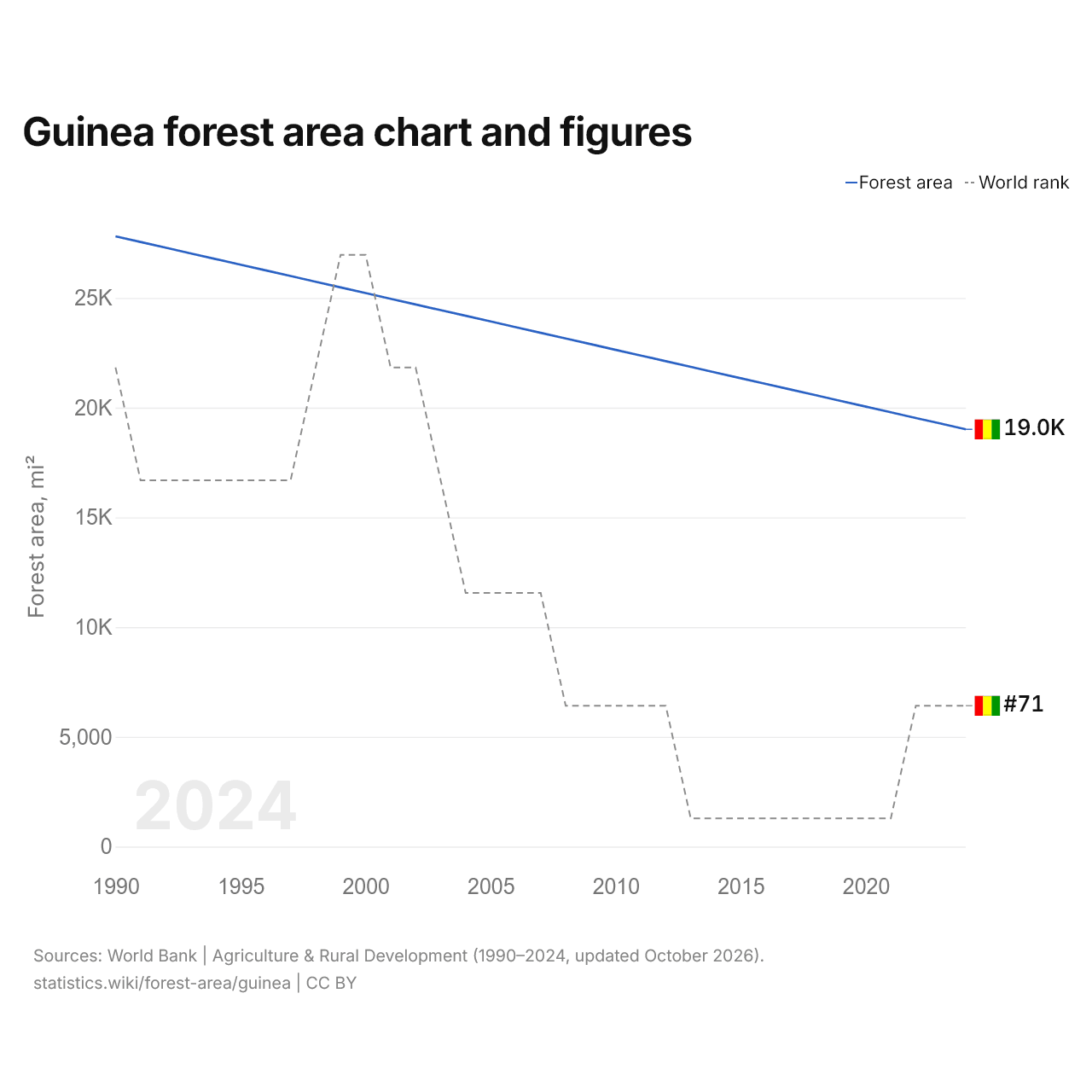
The forest area of Guinea is 19,013 mi² (49,243 km²), down from 27,808 mi² (72,022 km²) in 1990. It is the 71st largest in the world, a rank it has held since 2022. Its highest rank was 67th, last held in 2000.
Guinea's forest area is the 24th largest of the 54 countries of Africa, and 0.74% of the region's total. Forest covers 20.0% of Guinea's land area. Agricultural land in Guinea covers 69,470 mi² (179,926 km²), 3.7 times the forest area.
| Guinea forest area, 2024 | 19,013 mi² |
|---|---|
| Forest area, % of land area, 2024 | 20.0% |
| World rank by area | #71 of 196 |
| World rank by % of land area | #122 of 196 |
| Forest area per person, 2024 | 0.82 acres per person |
| Net change of forest area, 1990–2024 | −31.6% |
Guinea in the world ranking of forest area

Compare the forest area of Guinea with other countries
Sources:
- World Bank | Agriculture & Rural Development (1990–2024, updated October 2026)
Creative Commons Attribution (CC BY): you may copy, share, adapt and reuse this content, also commercially, as long as you credit statistics.wiki and note any changes you made. The sources listed above may have their own license terms.