
Bhutan forest area chart and figures
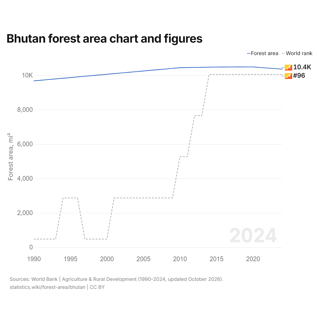
| Year | Forest area, mi² | World rank |
|---|---|---|
| Forest area | ||
| 2024 | 10,360 | #96 |
| 2023 | 10,393 | #96 |
| 2022 | 10,426 | #96 |
| 2021 | 10,458 | #96 |
| 2020 | 10,491 | #96 |
| 2019 | 10,490 | #96 |
| 2018 | 10,488 | #96 |
| 2017 | 10,487 | #96 |
| 2016 | 10,485 | #96 |
| 2015 | 10,483 | #96 |
| 2014 | 10,476 | #96 |
| 2013 | 10,468 | #97 |
| 2012 | 10,461 | #97 |
| 2011 | 10,453 | #98 |
| 2010 | 10,445 | #98 |
| 2009 | 10,407 | #99 |
| 2008 | 10,368 | #99 |
| 2007 | 10,330 | #99 |
| 2006 | 10,292 | #99 |
| 2005 | 10,254 | #99 |
| 2004 | 10,215 | #99 |
| 2003 | 10,177 | #99 |
| 2002 | 10,139 | #99 |
| 2001 | 10,100 | #99 |
| 2000 | 10,062 | #100 |
| 1999 | 10,024 | #100 |
| 1998 | 9,985 | #100 |
| 1997 | 9,947 | #100 |
| 1996 | 9,909 | #99 |
| 1995 | 9,870 | #99 |
| 1994 | 9,832 | #99 |
| 1993 | 9,793 | #100 |
| 1992 | 9,755 | #100 |
| 1991 | 9,717 | #100 |
| 1990 | 9,678 | #100 |
The forest area of Bhutan is 10,360 mi² (26,832 km²), up from 9,678 mi² (25,067 km²) in 1990. Its forest area was largest in 2020, at 10,491 mi² (27,172 km²). It is the 96th largest in the world, a rank it has held since 2014.
Bhutan's forest area is the 23rd largest of the 48 countries of Asia, and 0.43% of the region's total. Forest covers 70.4% of Bhutan's land area. Agricultural land in Bhutan covers 2,035 mi² (5,270 km²), 20% of the forest area.
| Bhutan forest area, 2024 | 10,360 mi² |
|---|---|
| Forest area, % of land area, 2024 | 70.4% |
| World rank by area | #96 of 196 |
| World rank by % of land area | #16 of 196 |
| Forest area per person, 2024 | 8.38 acres per person |
| Net change of forest area, 1990–2024 | +7.0% |
Bhutan in the world ranking of forest area
| Rank | Country | Forest area, mi² | % of land area | Net change since 1990 | |
|---|---|---|---|---|---|
| 93 |
 Costa Rica |
11,529 | 59.1% | +8.2% | |
| 94 |
 Czech Republic |
11,426 | 38.4% | +3.9% since 1993 | |
| 95 |
 Saudi Arabia |
10,711 | 1.3% | +0.2% | |
| 96 |
 Bhutan |
10,360 | 70.4% | +7.0% | |
| 97 |
 Solomon Islands |
9,709 | 89.8% | −1.0% | |
| 98 |
 Sierra Leone |
9,483 | 34.0% | −21.5% | |
| 99 |
 Estonia |
9,445 | 57.2% | +10.6% since 1992 |
Compare the forest area of Bhutan with other countries
Sources:
- World Bank | Agriculture & Rural Development (1990–2024, updated October 2026)
Creative Commons Attribution (CC BY): you may copy, share, adapt and reuse this content, also commercially, as long as you credit statistics.wiki and note any changes you made. The sources listed above may have their own license terms.