
Trinidad and Tobago vs Guyana agricultural land area chart
1x
| Year | Agricultural land, mi² | |
|---|---|---|
| Trinidad and Tobago | Guyana | |
| 2024 | 230 | 2,780 |
| 2023 | 208 | 2,780 |
| 2022 | 208 | 2,788 |
| 2021 | 208 | 2,785 |
| 2020 | 208 | 2,781 |
| 2019 | 208 | 2,778 |
| 2018 | 208 | 2,775 |
| 2017 | 208 | 2,771 |
| 2016 | 208 | 2,771 |
| 2015 | 208 | 2,771 |
| 2014 | 208 | 2,771 |
| 2013 | 208 | 2,771 |
| 2012 | 208 | 2,771 |
| 2011 | 208 | 2,771 |
| 2010 | 208 | 2,771 |
| 2009 | 208 | 2,771 |
| 2008 | 208 | 2,769 |
| 2007 | 208 | 2,764 |
| 2006 | 208 | 2,767 |
| 2005 | 208 | 2,767 |
| 2004 | 212 | 2,759 |
| 2003 | 232 | 2,765 |
| 2002 | 232 | 2,763 |
| 2001 | 232 | 2,776 |
| 2000 | 259 | 2,762 |
| 1999 | 259 | 2,758 |
| 1998 | 255 | 2,758 |
| 1997 | 274 | 2,758 |
| 1996 | 293 | 2,758 |
| 1995 | 293 | 2,754 |
| 1994 | 313 | 2,746 |
| 1993 | 313 | 2,746 |
| 1992 | 313 | 2,746 |
| 1991 | 313 | 2,746 |
| 1990 | 297 | 2,746 |
| 1989 | 278 | 2,746 |
| 1988 | 278 | 2,739 |
| 1987 | 274 | 2,739 |
| 1986 | 274 | 2,739 |
| 1985 | 274 | 2,731 |
| 1984 | 286 | 2,731 |
| 1983 | 286 | 2,719 |
| 1982 | 340 | 2,915 |
| 1981 | 367 | 3,110 |
| 1980 | 390 | 3,306 |
| 1979 | 409 | 3,501 |
| 1978 | 409 | 3,697 |
| 1977 | 409 | 3,892 |
| 1976 | 409 | 4,088 |
| 1975 | 409 | 5,320 |
| 1974 | 429 | 5,313 |
| 1973 | 425 | 5,313 |
| 1972 | 390 | 5,305 |
| 1971 | 390 | 5,293 |
| 1970 | 378 | 5,293 |
| 1969 | 378 | 5,274 |
| 1968 | 378 | 5,274 |
| 1967 | 378 | 5,266 |
| 1966 | 378 | 5,266 |
| 1965 | 378 | 5,247 |
| 1964 | 378 | 5,247 |
| 1963 | 378 | 5,247 |
| 1962 | 375 | 5,247 |
| 1961 | 375 | 5,247 |
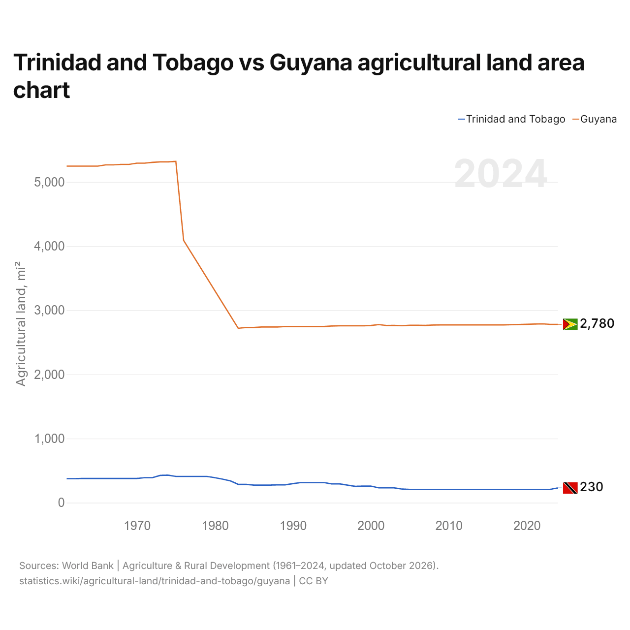
Agricultural land covers 230 mi² (595 km²) in Trinidad and Tobago and 2,780 mi² (7,200 km²) in Guyana: Guyana's agricultural land is 12 times Trinidad and Tobago's. In 1961, Trinidad and Tobago had 375 mi² (970 km²) and Guyana 5,247 mi² (13,590 km²); Guyana's agricultural land was then 14 times Trinidad and Tobago's.
Agricultural land covers 11.6% of Trinidad and Tobago's land area and 3.4% of Guyana's; arable land covers 5.8% and 0.4%.
Trinidad and Tobago vs Guyana: agricultural land, area and % of land area
 Trinidad |
 Guyana |
|
|---|---|---|
| Agricultural land | 229.8 mi² | 2,780 mi² |
| Agricultural land, % | 11.6% | 3.4% |
| Arable land | 115.8 mi² | 366 mi² |
| Arable land, % | 5.8% | 0.4% |
| Permanent crops | 90 mi² | 120.3 mi² |
| Permanent crops, % | 4.5% | 0.1% |
| Meadows and pastures | 24 mi² | 2,293 mi² |
| Meadows and pastures, % | 1.2% | 2.8% |
| Arable land per person | 0.05 acres per person | 0.28 acres per person |
| World rank by agricultural land | #168 of 194 | #145 of 194 |
| World rank by arable land | #161 of 191 | #150 of 191 |
| World rank by arable land per person | #167 of 191 | #100 of 191 |
Compare the agricultural land of any 2 countries
Sources:
- World Bank | Agriculture & Rural Development (1961–2024, updated October 2026)
Creative Commons Attribution (CC BY): you may copy, share, adapt and reuse this content, also commercially, as long as you credit statistics.wiki and note any changes you made. The sources listed above may have their own license terms.