
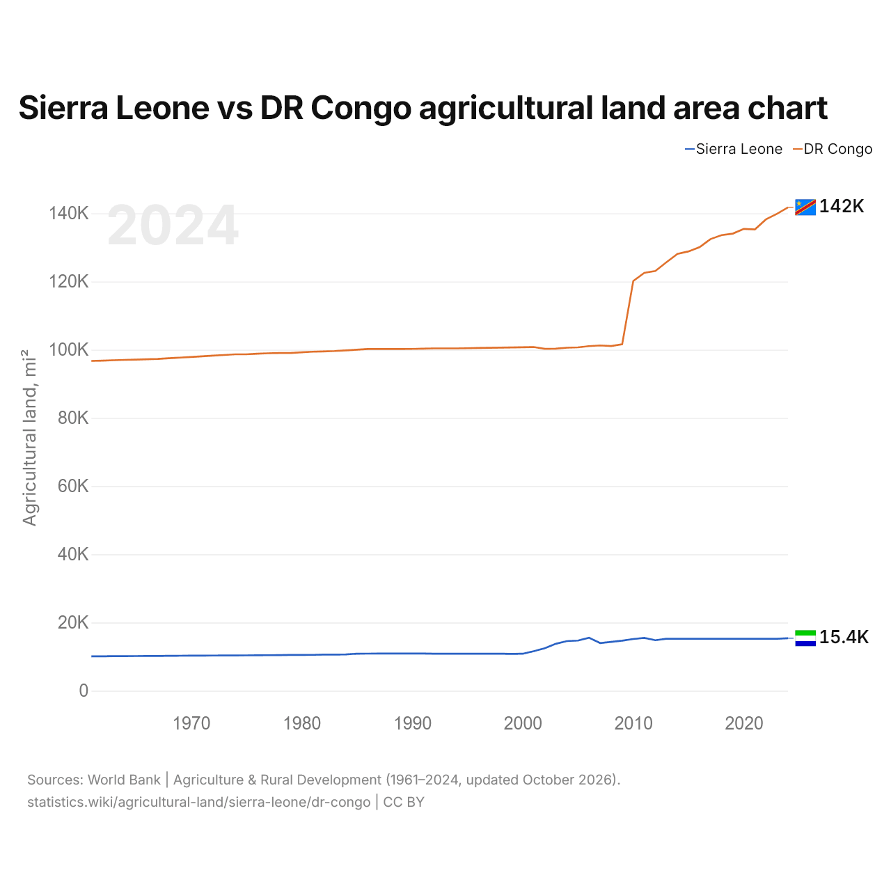
Sierra Leone vs DR Congo agricultural land area chart
1x
| Year | Agricultural land, mi² | |
|---|---|---|
| Sierra Leone | DR Congo | |
| 2024 | 15,396 | 141,736 |
| 2023 | 15,247 | 139,847 |
| 2022 | 15,247 | 138,221 |
| 2021 | 15,247 | 135,267 |
| 2020 | 15,247 | 135,428 |
| 2019 | 15,247 | 134,046 |
| 2018 | 15,247 | 133,596 |
| 2017 | 15,247 | 132,465 |
| 2016 | 15,247 | 130,074 |
| 2015 | 15,247 | 128,834 |
| 2014 | 15,247 | 128,096 |
| 2013 | 15,246 | 125,643 |
| 2012 | 14,814 | 123,072 |
| 2011 | 15,512 | 122,545 |
| 2010 | 15,175 | 120,138 |
| 2009 | 14,676 | 101,614 |
| 2008 | 14,333 | 101,080 |
| 2007 | 13,991 | 101,251 |
| 2006 | 15,560 | 101,042 |
| 2005 | 14,718 | 100,689 |
| 2004 | 14,566 | 100,593 |
| 2003 | 13,771 | 100,326 |
| 2002 | 12,471 | 100,269 |
| 2001 | 11,589 | 100,792 |
| 2000 | 10,849 | 100,734 |
| 1999 | 10,826 | 100,676 |
| 1998 | 10,846 | 100,618 |
| 1997 | 10,846 | 100,560 |
| 1996 | 10,849 | 100,502 |
| 1995 | 10,849 | 100,444 |
| 1994 | 10,849 | 100,387 |
| 1993 | 10,853 | 100,387 |
| 1992 | 10,869 | 100,387 |
| 1991 | 10,907 | 100,309 |
| 1990 | 10,907 | 100,232 |
| 1989 | 10,907 | 100,194 |
| 1988 | 10,907 | 100,194 |
| 1987 | 10,904 | 100,194 |
| 1986 | 10,884 | 100,194 |
| 1985 | 10,865 | 100,000 |
| 1984 | 10,672 | 99,807 |
| 1983 | 10,614 | 99,614 |
| 1982 | 10,595 | 99,499 |
| 1981 | 10,537 | 99,421 |
| 1980 | 10,517 | 99,228 |
| 1979 | 10,498 | 99,035 |
| 1978 | 10,460 | 99,035 |
| 1977 | 10,421 | 98,958 |
| 1976 | 10,402 | 98,842 |
| 1975 | 10,382 | 98,649 |
| 1974 | 10,363 | 98,649 |
| 1973 | 10,344 | 98,456 |
| 1972 | 10,324 | 98,263 |
| 1971 | 10,305 | 98,070 |
| 1970 | 10,286 | 97,877 |
| 1969 | 10,266 | 97,684 |
| 1968 | 10,247 | 97,491 |
| 1967 | 10,209 | 97,298 |
| 1966 | 10,189 | 97,182 |
| 1965 | 10,170 | 97,105 |
| 1964 | 10,151 | 97,027 |
| 1963 | 10,131 | 96,912 |
| 1962 | 10,104 | 96,796 |
| 1961 | 10,085 | 96,719 |
Agricultural land covers 15,396 mi² (39,875 km²) in Sierra Leone and 141,736 mi² (367,095 km²) in the DR Congo: the DR Congo's agricultural land is 9.2 times Sierra Leone's. In 1961, Sierra Leone had 10,085 mi² (26,120 km²) and the DR Congo 96,719 mi² (250,500 km²); the DR Congo's agricultural land was then 9.6 times Sierra Leone's.
Agricultural land covers 55.2% of Sierra Leone's land area and 16.2% of the DR Congo's; arable land covers 21.9% and 7.3%.
Sierra Leone vs DR Congo: agricultural land, area and % of land area
 Sierra Leone |
 DR Congo |
|
|---|---|---|
| Agricultural land | 15,396 mi² | 141,736 mi² |
| Agricultural land, % | 55.2% | 16.2% |
| Arable land | 6,116 mi² | 63,767 mi² |
| Arable land, % | 21.9% | 7.3% |
| Permanent crops | 786 mi² | 7,698 mi² |
| Permanent crops, % | 2.8% | 0.9% |
| Meadows and pastures | 8,494 mi² | 70,271 mi² |
| Meadows and pastures, % | 30.5% | 8.0% |
| Arable land per person | 0.45 acres per person | 0.37 acres per person |
| World rank by agricultural land | #95 of 194 | #36 of 194 |
| World rank by arable land | #90 of 191 | #19 of 191 |
| World rank by arable land per person | #69 of 191 | #82 of 191 |
Compare the agricultural land of any 2 countries
Sources:
- World Bank | Agriculture & Rural Development (1961–2024, updated October 2026)
Creative Commons Attribution (CC BY): you may copy, share, adapt and reuse this content, also commercially, as long as you credit statistics.wiki and note any changes you made. The sources listed above may have their own license terms.